

Forecast provided by ESTOFEX
What does ESTOFEX forecast? ESTOFEX issues "Storm Forecasts" on a daily basis. These bulletins, accompanied by a map, address the threats posed by severe convective storms in Europe. The focus of the forecasts is the threat for hail, severe wind gusts, and tornadoes that these storms pose. Since May 1st 2009, the threat of excessive convective rainfall is included. Additionally, areas where lightning is expected are highlighted. To communicate the magnitude of the threat of hail, severe wind gusts, tornadoes, and excessive precipitation, ESTOFEX uses threat levels. Threat levels are issued based on the estimated probability of severe weather resulting from convective storms. A storm is considered severe or extremely severe when it is accompanied by one or several phenomena that meet the criteria listed below.
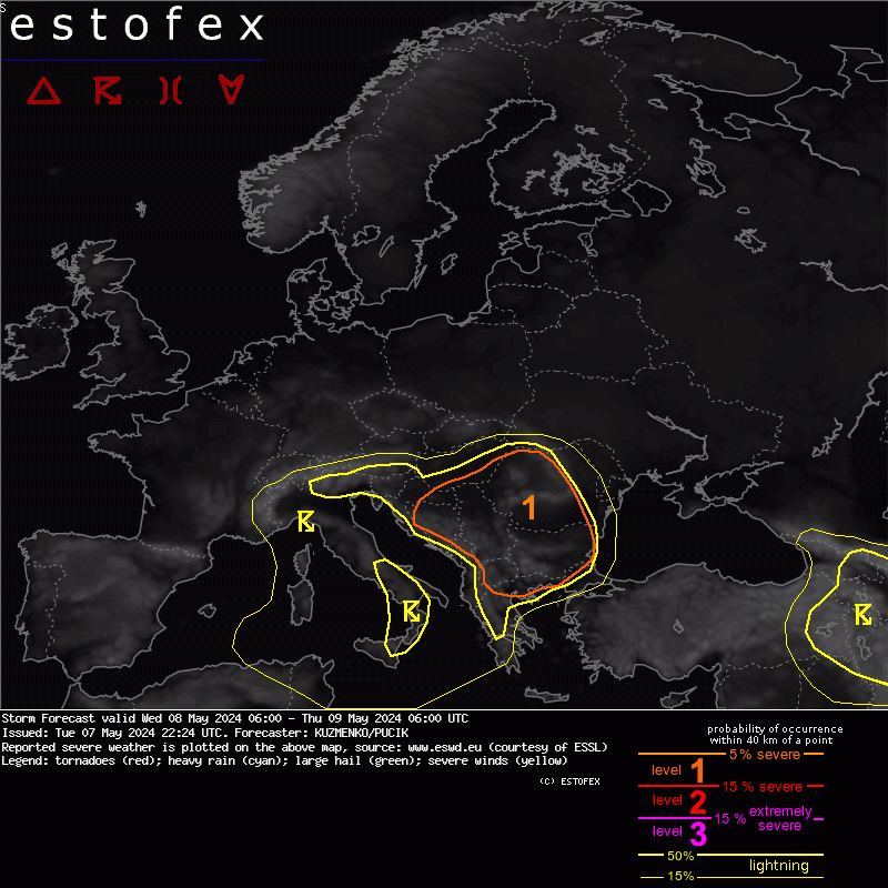
This level is valid for the area that does not fall under level 1, 2, or 3, implying that the expected probability of severe convective weather appears insignificant. There is 0-5% probability that a severe convective storm will occur within 40 km radius of a location. By the definition of probability isolines, the probability is just below 5% in the direct vicinity of level 1 contours.
Threat level 1 corresponds to a probability of 5% to 15% that a severe convective storm will occur within 40 km radius of a location. This is the most common threat level and is used when a low threat of severe weather has been identified.
Threat level 2 corresponds to a probability greater than 15% that a severe convective storm will occur within 40 km radius of a location. This is a significant threat that expresses larger confidence in the occurrence of severe storms. While extremely severe weather phenomena are not part of the criterion, there is a slightly increased probability for these as well (3-5%).
Threat level 3 is issued when there is a significant threat (probability greater than 15%) of extremely severe convective storms to occur within 40 km radius of a location. Level 3 is rarely issued and implies that a major severe weather outbreak is expected. Examples include the derecho (a thunderstorm system producing widespread extreme wind gusts) that struck a large part of Germany on July 10th 2002. Major tornado outbreaks also require a level 3. An example is the outbreak that occurred on June 25th 1967 across France, Belgium and the Netherlands, and the more recent case of tornadoes and large hail across Poland on August 15th 2008.

Apart from the threat areas, the maps show a yellow line: the areas where lightning is forecast. We are currently preparing to issue probabilistic lightning forecasts. The map will show two lines which separate areas with very low | medium | high probability of lightning to occur within 40 km radius of a location on the map.